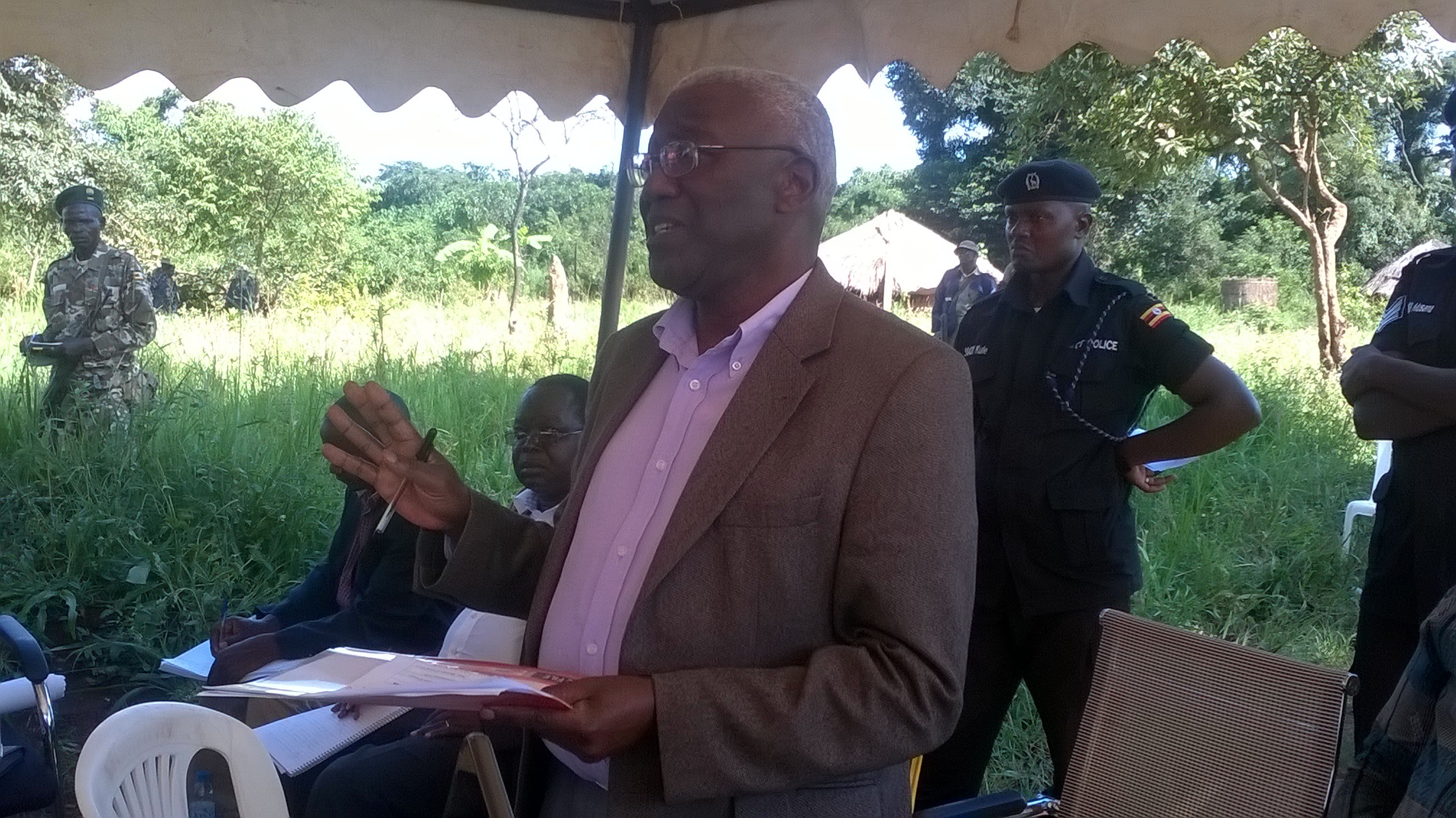
Tension remains simmering along the Amuru- Adjumani districts after Tom Butiime, the Minister of Local Government on Friday last week handed Apaa to Adjumani district officials.
The handover ceremony took place at Junction Corner in Labala parish, Pabbo Sub County in Amuru District. There was heavy security deployment in the area prior to the handover event.
Minister Butiime who was accompanied by his junior colleague, Minister Jenipher Namuyangu. The ministers said Apaa was now part of Adjumani and not Amuru.
Present at the ceremony was Amuru Resident District Commissioner Bilak Jalmoro, Amuru vice LCV Chairperson, John Bosco Ocan, Kilak North Member of parliament Anthony Akol and his counterpart from Adjumani Angel Mark Dulu. Also present was John Bayo Anyanzo, the Adjumani District Vice Chairperson.
Butiime explained that the government’s decision to give away the disputed land to Adjumani was based on the 1958 map that was drawn before independence.
The minister pointed out that the GPS coordinates had placed Apaa in Adjumani district and that contrary to what some had said, the coordinates of Apaa had not in any way been manipulated to place it in Adjumani.
The Minister warned any politician from Amuru district against campaigning in Apaa saying it will not be tolerated by government.
Further, the Minister instructed the Chief Administrative Officers (CAOs), for both Adjumani and Amuru to respect the decision and work within their new boundaries. He also called on called on religions and cultural leaders to preach peaceful co-existence between the Madi and Acholi.
But the placement of Apaa in Adjumani did not go well with Amuru leaders.
Anthony Akol, MP Kilak North protested the move saying due process had not been followed. The MP said he expected government to investigate the death early this year when several people were killed in Apaa over the disputed land before its ownership is resolved.
Akol added that he will raise his concerns before parliament.
John Bayo Anyanzo, the Adjumani District Vice Chairperson said he was happy with the government decision to finally settle the long running dispute.
Anyanzo told the two ministers that the Acholi on the land will not be victimized stating that the key concern was not ownership of the land but the administrative boundary of the land.
Government has also gone ahead to include Apaa as a village in Adjumani district leaving Amuru with 66 villages instead of the previous 67.
Electoral Commission in Adjumani has also been instructed to hold the November local council elections for Apaa as a village in Adjumani but not Amuru as had been the case.
Since 2012, Apaa has been a hotbed of violent clashes between the Acholi and Madi ethnic groups with each claiming rightful owners of the strip of fertile piece of land that is estimated to be around 44 square miles.
At least 14 local farmers have been killed since 2012 in deadly clashes between the communities.
The latest was in June this year where at least 10 farmer where killed by suspected Madi fighters who were armed with bow and arrow, machetes and spears.
5 Comments
DISPOSSESSION of Acholi at every turn. Colonial administration has no right in this matter – after all the were ruling “UGANDA / BUGANDA” according to their agreement of 1900. The Acholi were never a party to that agreement legally. The Uganda boundaries were spelled out in the 1900 agreement.
The British stole the Murchison Falls Game Park from both Bunyoro and Acholi without consultation. If this Apaa move stands then we want the Game park gazetted and returned to Acholi and Bunyoro Kingdoms administration since there were no agreements signed with the British administration and no compensation paid!! There!! You want to open old colonial wounds, then UGANDA as a state will not exist – only Buganda /”Uganda” who speak luganda and are called Baganda.
And Labwor county must be returned too. It was part of Acholi until Amin’s regime gave it away to Karamoja in the 70s.
I have researched the web and found the colonial maps of Uganda. The map of Uganda 1910 at:
. https://www.euratlas.net/history/hisatlas/africa/191000UG.html
Clearly shows the Northern region as Part of Anglo Egyptian Sudan.
Uganda Map of 1926 shows no Madi District. See map at
https://commons.wikimedia.org/wiki/File:Uganda_Protectorate_British_administration.png
And a warning to you Mr. President, do not wreck Uganda with your colonization of Uganda by your Rwandese and Hima bafoons agenda. Did you know that todate the place called West Nile has never belonged to Uganda. Please read this very important article on the West Nile.
https://eroti.wordpress.com/2014/01/11/history-information-notes-on-lado-maps-flags-and-the-postal-history-in-lado/
http://www.africaspeaks.com/reasoning/index.php?topic=4371.0
The same approach should be used by the ACHOLI to document their History. Also in the UN and all should understand the UN Declaration of the Rights of Ingenious Peoples
http://www.un.org/esa/socdev/unpfii/documents/DRIPS_en.pdf
Debates and negotiations are best backed up by FACTS and MOVES, BLUFFS etc.
SAME APPLIES TO LAND QUESTION – read Uganda History regarding land under the colonial system – no tempering with local customs.
There was no Madi in the Colonial Map of Uganda of 1926.
Google:
Uganda 1926 – no madi
https://commons.wikimedia.org/wiki/File:Uganda_Protectorate_British_administration.png
Museveni has no sense of understanding apart from dictatorship. He must know that he is an illegal president with no mandate of Ugandans. Museveni should be shown the door because he is sitting in that position illegally. Secondly, Museveni must know that he does not own Uganda as he madly thinks.